It appears that the notification for my last post wasn’t sent out for some reason – hopefully this one makes it passed my computer.
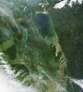
Just a short note to share the most recent clear satellite image of the lake, dated August 16th. This image shows the blooms intensifying somewhat in both basins of the lake, and the narrows. Not surprising given the weather we have experienced lately. The north basin bloom seems to be staying predominantly along the clear/turbid water interface on the east side north of Berens River. Similarly, the south basin bloom appears to be trying to take hold at that interface as well. Any protected nearshore areas will also be susceptible to surface bloom formation.
Also interesting is the intense erosion occurring along the north shore. Unfortunately, Two-Mile Channel is obscured by a small cloud, but you can still see how Playgreen Lake is impacted by the two outflows from Lake Winnipeg, the constructed Two-Mile Channel and the natural outflow at Warren’s Landing.
Reminder that the complete set of 2014 satellite images is in the image library above.
